
|
SCNA TRAVEL CORNER Travel Menu | So Cal Beaches | Hot Springs | Hiking | Other States| Cruises | Foreign Lands |
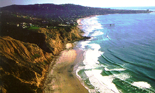
Let me begin by saying there are no easy way to Black's. There is either a steep climb, a long hike
or entry by water route (Note: access by water is done only rarely and very few do it.) There are several steep climb options, and there are two long hike options. Here are the directions, organized from north to south:
Steel Ball Indian Canyon Glider Port City Beach La Jolla Shores
Torry Pines Route
1. Exit interstate 5 at Carmel Valley Road and head west.
Glider Port Route:
1. Exit I-5 at Genesee and head west.
Black Gold Road:
1. Exit interstate 5 at La Jolla Village Drive and turn west.
La Jolla Shores Route
Torrey Pines State Beach Parking
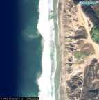
Flatrock
Mussel Rocks
(Nudity Boundary)
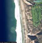
Torrey Pines Golf Course
<----
(Nudity Boundary)
Box Canyon
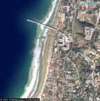
Scripps Pier
Long Hike North Route
Parking: Pay Lot
Path Description: Long Flat Hike
High Tide Concerns: Often Impassable at High Tide
2. Turn left at Camino Del Mar.
3. Enter through the gate and park where you can.
4. Walk to the beach and turn south, which is left.
5. Black's Beach is about 2 miles south.
6. At some point you will pass through a gap, called Flatrock.
7. On the seaside of that gap is a flat rock, usually in the surf.
8. Once you pass through that gap, you will see Mussel Rocks ahead of you.
9. Mussel Rocks is the northern boundary to the clothing optional section of the beach.
Steep Path Route
Parking: Dirt or Street
Slippery Path When Wet
2. Turn left on North Torrey Pines Road.
3. The next turn is close, the second signal. Turn right on Torrey Pines Scenic. It is
also marked by a sign for the Salk institute and the Glider Port.
4. Follow that road to the end.
5. At the end is a cul de sac and straight ahead is a driveway to a dirt road with a gate. I think the gate is only locked at night.
6. Pass through the gate and bear left.
7. Park near the glider port, or wherever you feel comfortable. Mud puddles linger for a few days after a
storm.
8. There is a path to the south of parking set apart by railroad ties. Follow that path, bearing left.
9. To your right is a small mosaic. Straight ahead you will see a few signs ahead. One describing beach access, another warning against night use, and a third listing more regulations.
10. To the left of those, the rugged trail to the beach begins. Most people wear hiking shoes on the steep winding path. Some regulars maintain a few steps near the end, then you will find a staircase leading to a narrow ravine with steps carved into the floor or the ravine.
11. The end of the trail changes periodically due to weather and vandalism. Sometimes there are sandbags arranged into a zigzagging ramp. Vandals and weather tear it apart, but the Black's Beach Diggers rebuild it often. During winter months the sand is often covered in mud from recent erosion.
12. Nudity is tolerated only a short distance to the left and far to the right.
Steep Path Route
Street Parking, Restricted Weekdays
2. Follow that street as it curves right and becomes North Torrey Pines Road.
3. Turn left at La Jolla Shores Drive then right onto La Jolla Farms Road.
4. Where La Jolla Farms Road meets Black Gold Road is the access road to Black's
Beach.
5. Vehicle access is controlled by UC San Diego, but pedestrian access
is unrestricted.
6. Parking is restricted on weekdays.It's a two hour zone. Park where ever you can find a space and walk back to the gate.
7. It's a one lane asphalt road that winds its way to the beach.
8. There is one place where you can take a steep shortcut. You will eventually reach a place with an outhouse and enough space to park a few cars. Continue down to the beach.
9. At this point you are on Torrey Pines City beach, which used to be called Black's Beach.
Nudity is prohibited there by local ordinance. You want to reach the southern edge of Torrey Pines State Beach. That is about 2/3 of a mile to the north. You will know you are still on the city beach
because you will occasionally see signs against the cliff stating that nudity is
prohibited.
10. Lifeguards often set up orange traffic cones and a sign marking the boundary
between the city and state beach. Once you reach that boundary, you are on
a part of the beach that we still call Black's Beach, despite the official name.
Long Hike North
Parking: Always in High Demand
Path Description: Long Flat Hike
High Tide Concerns: Often Impassable at High Tide