
|
SCNA TRAVEL CORNER Travel Menu | So Cal Beaches | Hot Springs | Hiking | Other States | Cruises | Foreign Lands |
NUDE HIKING IN THE SESPE CREEK AREA OF VENTURA COUNTY, CA
BACKGROUND ON SESPE CREEK
The Los Padres was originally established to protect the pristine water sources for the coastal communities surrounding the forest. Today, the Los Padres encompasses 1,134 miles of rivers and streams, providing water for urban and agricultural use, habitat for rare and at-risk species, and exciting recreation opportunities. Healthy and freeflowing waterways are a vital part of this landscape.
The major waterways in the forest are the Ventura and Santa Clara Rivers in Ventura County; the Santa Ynez River in Santa Barbara County; the Cuyama and Salinas rivers in San Luis Obispo County; and the Carmel River in Monterey County. In addition, Congress has designated 84 miles of “wild and scenic” rivers, including the Sespe, Sisquoc, and Big Sur rivers.
ForestWatch works to protect water quality, ensure adequate water supplies, and preserve riparian habitat in these and all of the 35 watersheds of the Los Padres.Our Rivers and Watersheds Program focuses on water quality, riparian habitat, wild and scenic rivers, dams, and water supply.
Distance: 3.5 miles round trip from parking area.
COMMENTS:
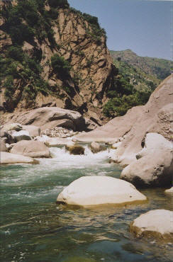
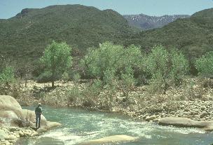
"This easy hike stays high on a bluff above the creek for most of the hike. Unless the water levels are pretty high, you really cannot see the stream unless you take one of the side trails down to the water. The topo map notes one particularly inviting side trail that drops down into a great swimming hole. This swimming hole is on the section stream below a grove of pine trees on the steep slopes on the far side of the stream. The turn around point is a metal gate part way up a shallow ridge. From this point you get a nice view of the Sespe creek and surrounding area. Also consider also hiking the Rose Valley Waterfall or the Piedra Blanca Formations if you are in this area."
DIRECTIONS:
GPS: Lat:34.56008 Lon:-119.16287
From Ojai, drive 15 miles north on Highway 33 to the Rose Valley turnoff and make a right.
Continue 5 miles to a road split, where you take the left branch for 1 mile to Lions Camp.
Park at the roads end near the trailhead, and cross the shallow creek. Look for a trail marker on the far side of the bank from the parking area.
Best Seasons: Fall, Winter, Spring
UPDATE: FIRE DESTROYS FOREST AREAS USED BY OUR MEMBERS FOR NUDE HIKING
September, 2006 - As the recent Day Fire burned its way across the Los Padres National forest for 28 days, it left behind 160,000 burned acres of watershed and hiking trails, many of them used by SCNA members for occasional nude hikes.
The fire, which stretched from Internate 5 to the east all the way to the hills above Ojai 30 miles away, also burned through the Sespe Creek watershed area, which many members have quietly used to take nude hikes on weekends. The burn area also stretched from Lake Piru and Highway 126 on the south to nearly Frazier park on the north, some 15 miles away. On this northern edge was Pine Valley, a little canyon also used by nude hikers and known for its rustic beauty, which partially burned.
Nude hikers will have to wait probably over a year until enough brush has re-grown before considering using the area again.
Elevation Gain: 200 ft
Hike Time: 2 hours
Difficulty: Easy
Trail Condition: Well maintained trail
HikeType: Out and Back
User Groups: Hikers, Dogs, Bikes, Horses
Ranger Contact: Las Padres National Forest, (805) 646-4348